GPS Facts
Posted by A. Douglas / in Science Facts
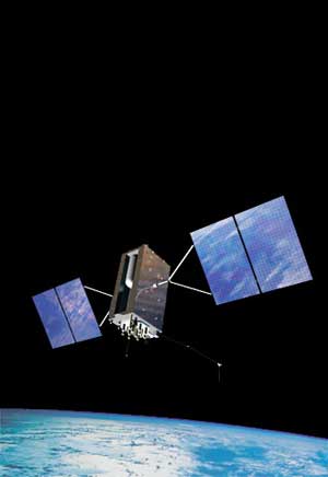
The GPS system requires satellites in space to work accurately
The fact is the Global Positioning System (GPS) is a technology that is here to stay. GPS is an extremely useful technology which is used by most people who have a modern smart phone. People have tried to build an accurate navigation system for land, air and water transportation for many years. The GPS system is a fulfillment of this desire to build a system that is accurate and easy to use. Learn more about the Global Positioning System by reading all of the GPS facts below.
The History of GPS
Throughout recorded history people have needed to have an accurate way of navigating around the Earth. Star navigation, the compass and radio wave navigation were all used by people before GPS was developed. Star and moon navigation were the closest to modern GPS. The problem with using the moon and sun for navigation was people did not fully understand their position vs. places on Earth. The sun and the moon only offered one-way communication. They could sometimes see light from the sun and moon, but could not send information back to help find their location on Earth. Also the sun and moon were not always visible to travelers.
- In the late 1950's USSR and the United States successfully launched artificial satellites into the Earth's atmosphere. The first satellites gave scientists an artificial source of communication that was independent from the sun, moon, and Earth.
- In 1959 the United States Navy sponsored a group of scientists at the Johns Hopkins Applied Physics Laboratory to devlop a navigation system. The research team led by Dr. Richard Kirschner, was able to study the satellites and create a system which used 3 satellites at any one time to locate objects on Earth. When the 3 satellites were in the correct position, it gave decent results. The success of this system opened up new ideas for a larger global system.
- From 1963-1973 the Army, Navy and Air Force independently work on separate systems to help them with navigation. In 1973 the United States Air Force is put in charge of a joint program to develop a satellite systems that the military can use for navigation and control of missiles and ground objects.
- On December 17, 1973 the NAVSTAR GPS system is approved. NAVSTAR is the military name for the current GPS system.
- On July 14, 1974 the first NAVSTAR satellite is launched into orbit around the Earth.
- On September 16, 1983 Approval was granted by President Ronald Reagan to make a portion of the GPS system data available for civilian use. This opened up options for airlines, ocean ships and other modes of transportation to use GPS for navigation. It also allowed land surveyors to develop new equipment to use the GPS data to accurately locate positions of objects on the Earth.
- The first cell phones to have working GPS were developed by Navsys Corporation for the Colorado Department of Transportation's emergency response system. The first GPS cell phone is on display at Smithsonian's Air and Space Museum in Washington D.C. Today, nearly all smart phones have the GPS feature.
How the GPS System Works
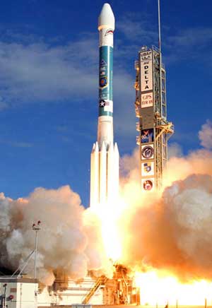
Launch of a GPS satellite - image credit: gps.gov
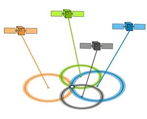
- The GPS system uses a minimum of 24 satellites which continuously circle around (orbit) the Earth.
- Each satellite orbits the Earth 2 times every day.
- Scientists have designed 6 different orbit paths that provide a continuous signal to all places on the surface of the Earth.
- To accurately provide a 3 dimensional location on the Earth's surface a GPS unit on Earth must receive a signal from 4 satellites. The precise location of each of the satellites is known.
- Objects on Earth can be located accurately with a GPS receiver. The receiver obtains data from each of the satellites to calculate its longitude, latitude, and elevation on Earth (x, y and z coordinates). It works by calculating the exact distance from each of the satellites using the atomic clocks on the satellites. Satellites send out GPS time data and their location data using radio waves, which travel at the speed of light. A GPS receiver on Earth receives the data. It then calculates the exact distance from each satellite by making a time correction. Distance = rate x time. Rate is a known constant value (the speed of light) and time is the difference in atomic clock time from when the signal was sent to when it was received.
- The current status of the GPS satellites are maintained by the U.S. Department of Homeland Security by the United States Coast Guard. Find the GPS satellite satatus here: https://www.navcen.uscg.gov/?Do=constellationStatus
- On June, 2011, the United States Air Force added 3 operational satellites to the 24 satellite GPS system. The 3 additional satellites improved coverage of the surface of the Earth and provided more backup capability if satellites fail. Typically there are now over 30 satellites that are part of the GPS system, with 27 satellites operating at any one time.
The Future of GPS
Huge advancements in GPS technology is close. More countries will soon follow the United States by developing their own satellite navigation system. Japan, China, India and more countries are developing their own space-based navigation system. What will happen when there are hundreds of satellites in orbit around the Earth?
- The United States announced development of a new satellite called the GPS III satellite
- This satellite system will have a new non-military radio frequency which will help all the satellites in space avoid each other.
- This satellite will have improved accuracy. It will provide this new communication channel to technology on Earth. This channel may greatly improve GPS receiver accuracy without requiring expensive equipment on Earth.
- This improvement could provide the capability for many new devices to have much better control with a very low cost.
- Automated car navigation systems (auto-pilot cars), enhanced cell phone accuracy and more may only be a some of the advancements in technology in the future because of GPS.
- A full constellation of the GPS III satellites is expected for launch and operation by the end of the year 2020.
- What do you think GPS will do in the future?
Launch of a GPS satellite - image credit: gps.gov
Please select the social network you want to share this page with:
We like you too :)
Thanks for taking time to give us feedback!

posted by Allen Douglas - Allen is a professional engineer, achieving a Master of Science in Engineering. He has taught at the university level, but enjoys helping younger students to learn about math and science. Mr. Douglas has been writing technical papers for over 20 years, and writing online articles since 2008.